The Township of Butterworth
Butterworth was a long-existing township within the southeast of the Parish of Rochdale, in The Salford Hundred, in Lancashire, England.
The centre of Butterworth was three miles east of the town of Rochdale.
It included the chapelry of Milnrow, the village of Newhey and the smaller hamlets of Clegg, Wildhouse, Belfield, Butterworth Hall, Lowhouse, Haughs, and Bleaked-gate-cum-Roughbank within its borders.
Butterworth also extended into territory which included Hollingworth Lake.
It was historically divided into two subdistricts; Butterworth Freeholdside and Butterworth Lordshipside. These 'sides' refer to the ancient terms of tenure, some freehold, some of the Lord of the Manor by various rents and services. Each 'side' had been accustomed to have a constable in the Rochdale manor court.
Read more about Butterworth Township here
Transcription From "The Parson's Book" by F.R. Raines
Written between the years 1841 and 1871
Census
The population of Butterworth, like all this part of Lancashire, has very greatly increased during the last half century. In 1715 the chapel was only calculated to accomodate 100 persons, which would be the major part of the Inhabitants. In 1775 Milnrow contained according to Mr Collier's MS.S. 284 Inhabitants. The average member of the Chapelry is not stated.
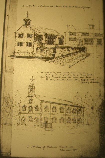
Milnrow Chapel Early and later
In 1801
it appears by the Census then taken, that Butterworth contained 3923 Inhabitants.
The population in 1811
was 4872; of these 133 families were engaged in Agriculture, and 725 were chiefly employed in Trade, Manufactures, or Handicraft.
In 1821
Butterworth contained 943 houses, 987 families, 5554 persons,
and the estimated annual value of the Lands,
Messuages &c [&etc] was £8283.
In 1831
the Population was 5648
In 1841
5688[?]
In 1851
comp.d 1115 houses - 129 uninhab. - 11 in building.
2942 males. 2844 females: total 5786
In 1861
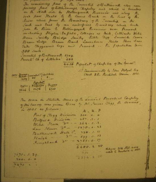
the populat. of the Township was 6704 - of the Chapelry of Milnrow 6018. See over [below]
***************************
Pg 14 [next page]
In 1861
the population of the ancient Parochial Chapelry of Milnrow amounted according to the Census, to 6018 souls.
Part of the Township of Butterworth is comprised in the old Parochial Chapelry of Littleborough, which is bounded on the North side by the Boundary between Blatchinworth and Calderbrook, and Butterworth on the East by the Yorkshire Moors, on the South and West by the road leading from Syke over the bank of Hollingworth Reservoir to Fisherman's Inn and from thence to Littleborough including Hollingworth; Higher Fold; Sykes Lane; Benny hill; Brearley; Sheepbank; Whitaker; Shore Lane; Owlet Hall; Station House; Railway Inghams; Newbarn Clough fold; Banktop; Cleggswood; Stanna and Fisherman's Inn -
the population being 298 souls.
[I've added semicolons ; to make the place-names more understandable. F R Raines omitted these in the original.]
The remaining part of the Township of Butterworth also comprising part of Littleborough Chapelry and which is bounded on the North side by Hollingworth Reservoir and along the road past Heald to the Canal Bank on the West[?] of the River which forms the Boundary of the Township on the South and East by an undefined Boundary which leads from the River to Hollingworth Reservoir near Peacock including Higher Eafield, Cottages at Mill, Calliards Water House; Smithy Bridge Smithy; Little Clegg; Laneside Corner; Brown Lodge; Brown Bank; Lowerhouse; Heald House[?] Lane Ends; Cleggswood Leys and Peacock
- the population being 388 souls.
[Again I've added semicolons ; to make the place-names more understandable. F R Raines omitted these in the original.]
[I think this is Acre- Rood- Pole/Perch-: -
Anglo-Saxon Weights & Measures]
A R P
Part of Clegg Division 200. 0. 0
Belfield Division 457. 3. 1
Wild House do - 264. 1. 3
Low House do - 1278. 0.23
Butterworth Hall do - 738. 1.11
Halgh - - - do - 599. 0.13
Roughbank - - do - 2751. 0.17
----------------
6688. 2.28
Deduct 314 Stat Acres 314. 0. 0
ceded to Newbold
in 1868
6374. 2. 28
7671. 1.39 [Written at bottom of sheet - unexplained]
200. 0. 0
7474. - -
[End of Transcription]
Extract from the Parson's Book Written by F R Raines
Messuages (OED definition)
Origin: Late Medieval English (Ancient French - messuage, mesuage)
Originally the portion of land intended for the site for a dwelling-house and its appurtenances. In modern legal use, a dwelling-house with its outbuildings and curtilage and the adjacent land assigned to its use.
Back to Parson's Book
If anyone who is researching the family history of families in the Bury, Rochdale and Milnrow area would like to contact me please email
moderator@caryb.co.uk.Please put "CB Family History" in the subject.